About
I have a broad interest in the application of geospatial and remote sensing technologies to address environmental and societal challenges at scale. I hold a PhD in Remote Sensing & Oceanography, but since then I have branched out into data science, geospatial analysis, and software development. I’m particularly excited by the convergence of physics-based simulations (especially radiative transfer), remote sensing and machine learning. Take a look at my portfolio, and if you’d like to collaborate, please don’t hesitate to get in touch!
Check out my latest work
I've collaborated on a variety of projects with multiple research institutes and clients. Most of my work revolves around using optical imagery to monitor and analyze our changing planet.
Advancing water quality monitoring from space
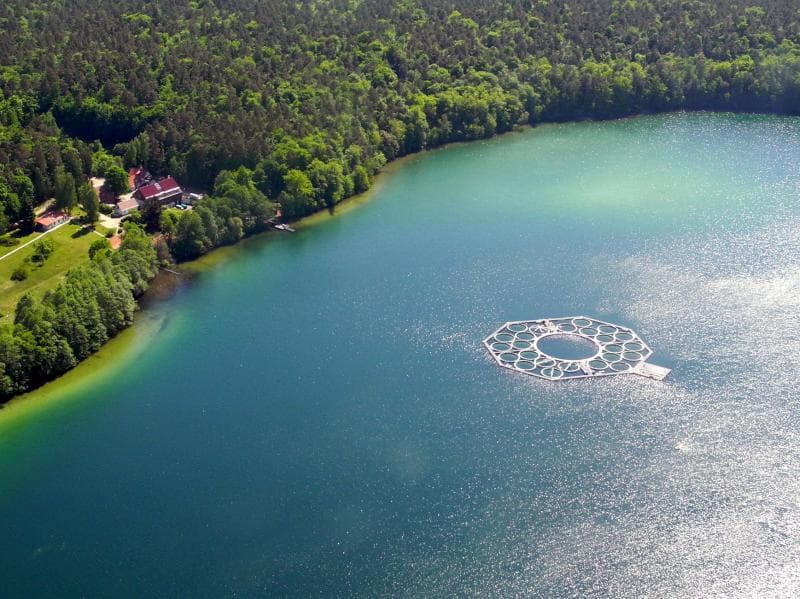
Optical satellite imagery is used to monitor water quality from space. On behalf of a client, I implemented a physics-based inversion model to derive indicators such as chlorophyll-a from ESA Sentinel-2 satellite. The analysis focused on lakes and rivers in Germany and the United States.

Underwater hyperspectral imaging
In this article, we describe the use of underwater RGB and hyperspectral imaging to map the seafloor at centimeter-scale resolution. From the ingestion of raw data to insights into biodiversity, biomass and ecosystem health. This technology demonstrates the potential for precise, large-scale carbon assessment of aquatic ecosystems.

Physics-based inverse modelling of multi- and hyperspectral observations
A scientific paper published during my PhD, presenting the development and validation of a physics-based model for both forward and inverse simulations. The model enables the simulation of optical signals measured by multi- and hyperspectral ocean-observing satellites.

Hyperspectral image processing at scale
In this article, I outline the steps involved in processing large volumes of hyperspectral data, including the essential groundwork required before the data can be used for further analysis. The work focuses on implementing radiometric, geometric and water column correction models.
Collaborated with


Services
I provide a variety of services catered to geospatial and remote sensing data
Geospatial and Remote Sensing Analysis
Software Development
Data Visualization
Work experience
Geospatial Data Engineer
dClimate Labs
🇺🇸 New York, NY, United States
• Designed and maintained ML training and inference pipelines for geospatial foundational models fusing optical and SAR satellite imagery. • Built scalable cloud infrastructure for large-scale dataset ingestion, tiling and distributed chunk processing using Prefect, Docker, and Dask. • Productionized scientific algorithms with CI/CD and MLflow experiment tracking to monitor model performance. • Led a cross-functional team of developers and scientists to develop state-of-the-art geospatial data pipelines within an agile work environment.Data Scientist & Geospatial Consultant
Planblue GmbH
🇩🇪 Bremen, Germany
• Led hyperspectral cal/val campaigns, ensuring radiometric accuracy and product reliability through reference standards and in-situ measurements. • Implemented automated validation workflows and quality control for raw sensor data and end-user data products. • Specified requirements and implemented solutions for geospatial data processing and storage using Xarray and Zarr. • Delivered analysis-ready geospatial data products as GIS compatible raster filesSenior Data Scientist
Planblue GmbH
🇩🇪 Bremen, Germany
• Led development of end-to-end hyperspectral processing pipelines (Level 0 to Level 3) with automated quality controls, covering radiometric and water column correction. • Spearheaded acquisition of a new optical sensor; designed and executed calibration campaigns to ensure precise spectral reflectance measurements. • Interfacing between data science, engineering and business teamsRemote Sensing Consultant
Gybe (Flying Gybe Inc.)
🇺🇸 Portland, Oregon, United States
• Implemented a Dockerized physics-based inversion framework for cloud processing of Sentinel-2 imagery. • Validated retrievals of water quality parameters against in-situ measurements from lakes and rivers in Germany and the US.PhD Remote Sensing & Oceanography
Vrije Universiteit Amsterdam
🇳🇱 Amsterdam, The Netherlands
• Developed and validated a physics-based inversion framework for multi- and hyperspectral sensors (HYDROPT) • Developed processing pipelines for hyperspectral radiative transfer simulations • Published research and presented at international conferences.Guest Researcher
University of Amsterdam
🇳🇱 Amsterdam, The Netherlands
• PhD guest researcher conducting research on in-water radiative transfer and bio-optical modelsVisiting Research Scientist
Scripps Institution of Oceanography
🇺🇸 La Jolla Shores, California, United States
• Developed bio-optical models for a physics-based inversion framework for hyperspectral ocean color observations.
Education
University of Amsterdam
University of Queensland
University of Amsterdam
Technical University Twente
Skills
To learn is to grow. To teach is to give
Here you'll find a selection of workshops and training sessions I've attended, events where I've presented my work to wider audiences, and courses and workshops I've taught.